Opening hours
Tues-Sat, 1-5pm
extended openings
14-15-16: 1-9pm/
Sat 18 Oct: 10am-6pm
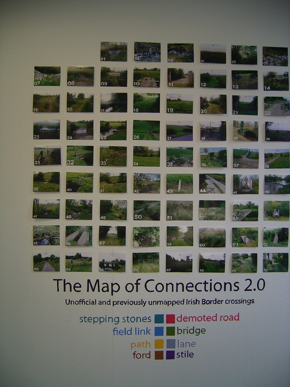
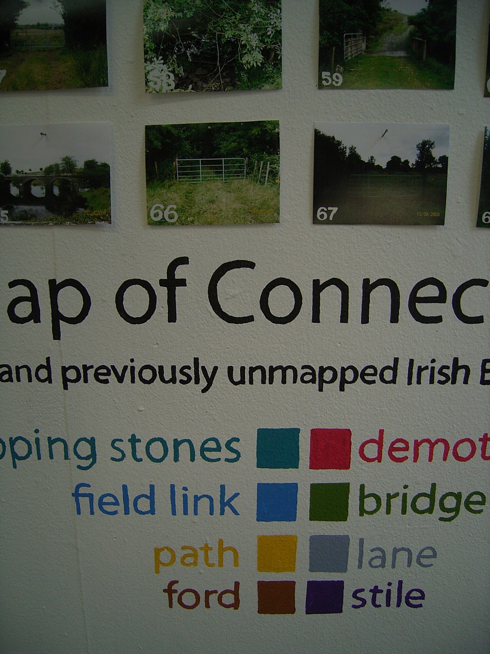
Map of Connections
The Map of Connections 2.0 & The Map of Encounters'
Garrett Carr
Ends 25 October 2008
This
project documents the artist/ geographer's undertaking to map the border
between the North and the South of Ireland in a very different way; objective
in its methods but poetic and individualistic in its
observations.
During his many walks, Garrett Carr drew a map of unofficial border crossings,
not found on any other map, took photographs and noted down his
encounters.
In his introduction he writes: ”I am making Post-Nationalist maps of
Ulster’s Border region. This means exploring the border mile by mile then
returning to the studio to produce maps of what I have found there… Cartography
can belong to us just like literature, painting or photography. It can be
claimed by individuals. We can be mapmakers using this powerful tool to express
what is important to us. That is what I am doing here. My maps will re-think
border signs and replace them with responsive and progressive symbols.”
A multidisciplinary approach of a single person, equipped with GPS and
poetic imagination, as much tales from a border as exact new
details.
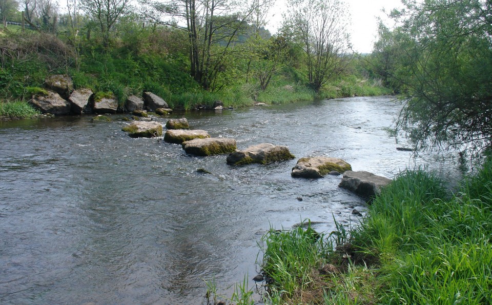
The 'Map of Connections' represents the border as a meeting place as much as a
division, and reveals traces of human movement found on the ground.
For more information see project blog www.newmapsofulster.net
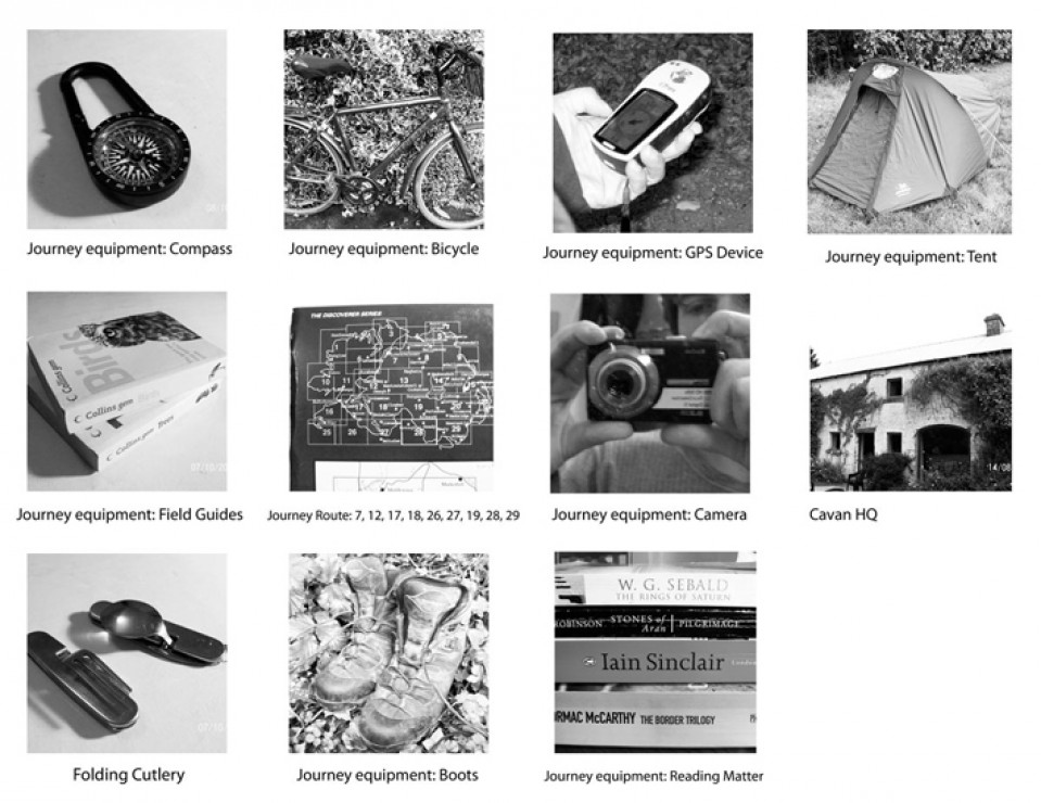
Garrett Carr: Map of connections-Equipment: Compass; Bicycle; GPS devise; Tent; Field Guides; Journey Route: 7,12, 17,18,26, 27, 28, 19, 29; Camera; Cavan HQ; Folding Cutlery; Boots; Reading Matter.
Garrett Carr: Why Remap the Border?
My work questions the traditional representation of borders as lines. I seek to replace borderlines with other symbols that are as accurate but different and progressive.
The urge of a people to self-present, to self
determine, leads to the rise of new nationalisms, then counter-nationalism,
and on and on. For example, recently Georgia broke from Russia, drawing a new
border, then South Ossetia broke from it, also seeking to demark a
representative territory. Borderlines are nationalism representation on maps.
For my work, looking at new ways to cartographically describe borders, I did
not need to travel as far as the Eastern Block. Ireland followed the same
pattern. A successful nationalist movement made the Irish Sea a border. This
turn created a counter-nationalism; Unionism and another Border was drawn. But
no matter how far a land is subdivided someone invariably is overwritten by the
process. The citizens of Free Derry once painted a white line around
their territory. It ran across streets and along alleyways and for a time actually
created an autonomous zone. The police and army did not cross it. This border
was never found on official maps of course, that was the very reason they
painted it themselves. Suppose Free Derry had been officially recognized
and mapped and then dissenters arose inside this new state? Further
subdivisions might have been called for. Then more. Eventually the map might
have been cut back down to the basic building block of nationalism, the family
home. Even there, behind closed doors, might be found divergent tendencies,
spite loyalties.
To develop a new mode of mapping the Irish Border I had to see it. Loss of contact with the ground was “the primary sin of the colonist,” as Paul Carter has written. So, I am travelling every mile of the Border, by foot and bicycle, and only map what I see with my own eyes. Back in the studio my maps are developed with the same hardware and software as used by the Ordnance Survey. Appropriating the tools of official cartography is practical but also fitting. We would not place much importance on state-produced literature or film, yet state cartographies are accepted almost completely. I believe cartography too can be claimed and conducted by independent practitioners. I am currently making three maps; The Map of Watchful Architecture, The Map of Connections, and The Map of Encounters.
The Map of Encounters is an attempt to take the borderline and widen it into a space of possibility, a place where things happen. The German poet Christian Morgenstern described an architect with similar ambition about one hundred years ago.
One time there was a picket fence with space to gaze from hence to thence. / An architect who saw this site approached it suddenly one night, / removed the spaces from the fence / and built from them a residence / the senate had to intervene / The architect, however, flew to Afri- or Americoo.
The architect took a boundary and converted it into a space. He is disruptive and a delinquent, forced in the end to leave the country, but I believe he was performing an essential duty. I tour the Border, carving the new land charted by the Map of Encounters. This map is an attempt to show the Border as a space to be in, not just a place to pass through.
When plotting connections for The Map of Connections a new graphic description of border seemed to open up. Here we have the Border turned into a series of perpendicular dashes, widening it into a zone of meeting. The connection lines seem to serve as stitches, binding rather than dividing. It is of course porous and open, again reflecting the actual condition of the Border as I found it on the ground. Perhaps the central principal in the creation of The Map of Connections and The Map of Encounters was to see everything with my own eyes, and with eyes wide-open, as if seeing everything for first time.

From the
Map of Encounters:
The apple Tree at the end of the border
I have just walked what might be called the beginning or the end of the
Border (I travel non-sequential sections). This is the winding way from
Jonesborough to Carlingford Lough. Much of Ireland’s border has been pinned to
rivers so I am often walking riverbanks. Cows, perhaps related but valued in
different currencies, look at each other across narrow waters.
The dusty-purple fruit of the blackthorn are plentiful. Blackthorns are the
bricks and mortar of hedgerows in this part of the country. Their berries can
be fermented into Sloe Gin but they are not suited to the immediate needs of
the walker. For me to eat are the blackberries. Their thorny shoots emerge from
the hedgerows and arc downward as if for my convenience. I throw blackberries
in my mouth as I walk. Try to forget the familiarity of these plants and look
at them afresh. Then perhaps a clump of Ulster brambles could suggest as much
exotic generosity as a coconut palm or an orange tree.
The land
border ends at Carlingford Lough and there, rooted right in the border itself,
is an apple tree. (Location; Ele 13m IJ 11754 ITH 19475, Irish Grid) It is
squeezed into the last few feet of soil, before the border dips into saltwater.
This is a real find. Apple trees growing wild are unusual enough but at this
location the tree is startling and resonant.
A fairytale kind of landmark, I almost do not want to tell you about it.
The tree’s limbs loll invitingly, asking to be relieved of their burden of
fruit.
I go to their aid.
The mobile Library
Thank you to Ken, the mobile librarian who brought me on his Border run. I was just after a freezing night in my tent on the Donegal Border (location; G64999 H07775, Irish Grid). It was my very first survey walk, from Pettigo to Lough Awaddy. I was ready to go home and down on the main road I was looking for a lift to Enniskillen. A lift in a mobile library was a first for me and I spent the day with Ken the end. We stopped at a couple of schools where I played library assistant. I was interested to hear about the mobile librarian’s cross-border initiatives. I hope I’ll bump into Ken again in future Border travels.
Quinns Quarry
“It’s an ugly place, all the trees are covered in grey dust.” These are the
words of a Fermanagh woman I meet. She is speaking about the territory of the
Mighty Quinn, local business living-legend. “But,” she adds, “I have to admit,
he has half the county employed.”
Follow
the road south to Ballyconnell and you pass through his empire. Vast sheds
contain a family of industries. Quinn Radiators, Quinn Packaging, Quinn Cement,
Quinn This, Quinn That ... My car happens to be covered by Quinn insurance.
Leave it parked near his works and, sure enough, it will soon be covered in
Quinn dust. Between the smoking and churning factories the Border pushes
through and on up Slieve Rushen. For Quinn does not just have half of Fermanagh
employed but half of Cavan too. His empire is both sides of the Border. I walk
up a Border-hugging lane, the tallest stacks of the Quinn cement factory always
in view. The lane turns and so to stick to the Border I go off-lane through the
trees. I come across ruined cottages, not an unusual sight anywhere in Ireland
but here somehow strange with the massive machines rumbling nearby. Pushing on
I begin to hear a regular beep-beep from somewhere up ahead. It is the warning
sound produced by a truck in reverse. Where can it be coming from? I am half
way up a steep mountain and there is no road near according to my map.
I push through more undergrowth and a suddenly a great hole in the world opens
up beneath me. Quinn’s quarry.
From: Garrett Carr project blog www.newmapsofulster.net.